Madeira Hiking, Trail Running resources
Madeira has a crazy amount of trails to choose from with a variety of difficulty levels. Some of these trails are famous, being featured on ads or Instagram reels and some are not so much. That’s why there is a big difference in how crowded these trails are.


There are 20+ local-recommended routes. These are numbered with PR <some number>. These are frequently maintained, have thorough signage on the path, have parking spaces at their trailheads and are easy to navigate and get information on thanks to the government website.
But these are not the only possible trails you can follow. There are plenty of other paths you might stumble upon if you go exploring. But since Madeira is an island of heavy rain which makes the soil very soft and prone to landslides and there are scary cliffs everywhere, it is recommended to not be too reckless when exploring.
The local-recommended trails list: https://ifcn.madeira.gov.pt/atividades-de-natureza/percursos-pedestres-recomendados/percursos-pedestres-recomendados.html
Due to heavy rains, rock falls or maintenance some trails might be closed. It is a good idea to check whether the trail you want to walk is open on the government website linked above. These closures are serious. People have gotten stranded in tunnels, got injured badly or even lost their lives when they ignored the warnings. So please don’t attempt closed trails.
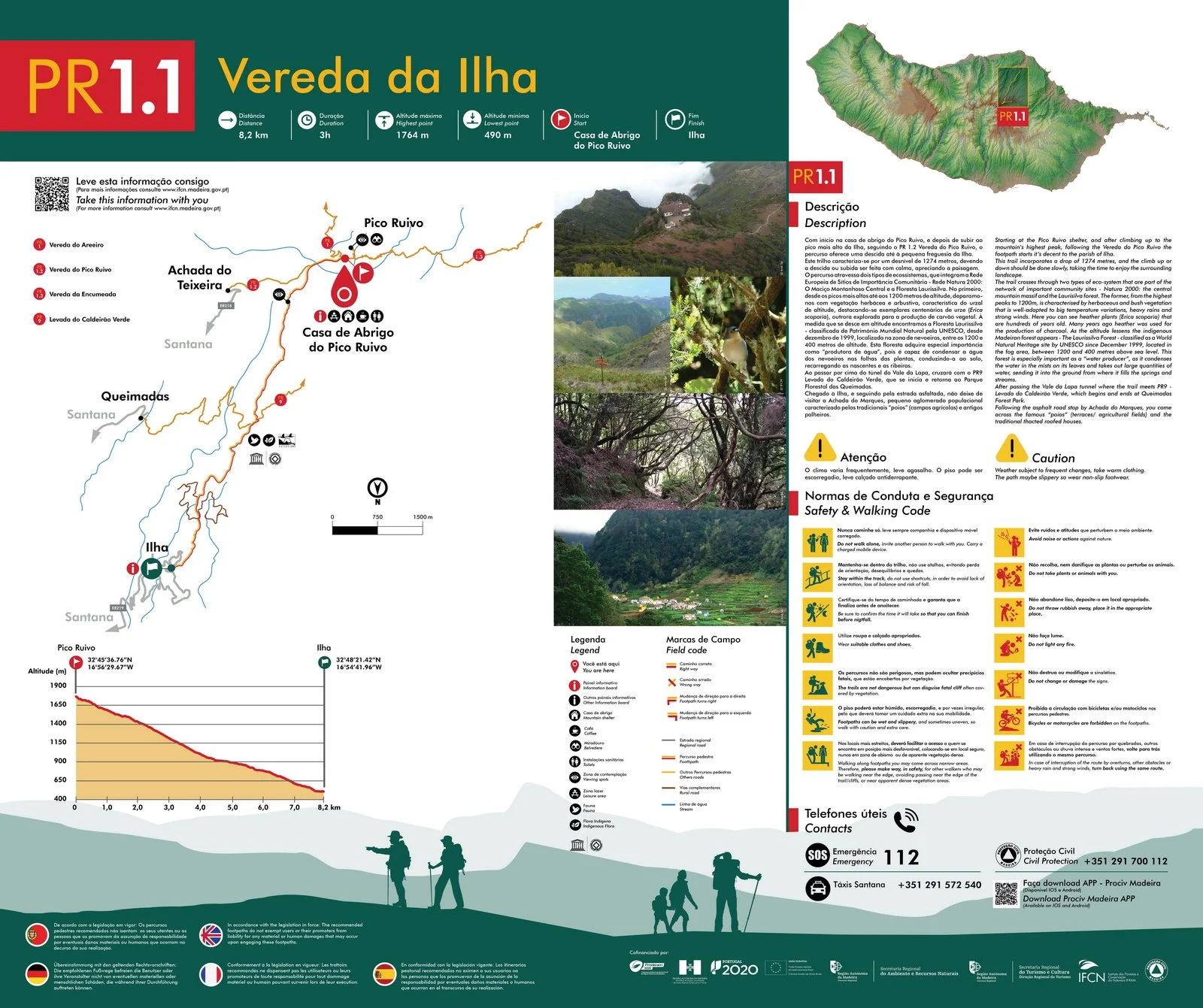
Example trail guide.
If you click the small icon to the left of the PR number of the trail, you will get a helpful info sheet with a map, gradient and a description of the trail like the one below. These maps are also found at the trailheads. Save these maps to your phone before starting the hike. Navigating might get tricky.
Trails I recommend
I have not been to all the trails on Madeira. So there definitely are trails that are worth visiting outside of this list. But, based on all the trails I’ve hiked/run, these are my favorites.
These are also some of the more challenging hikes. The island offers plenty of routes for all levels.
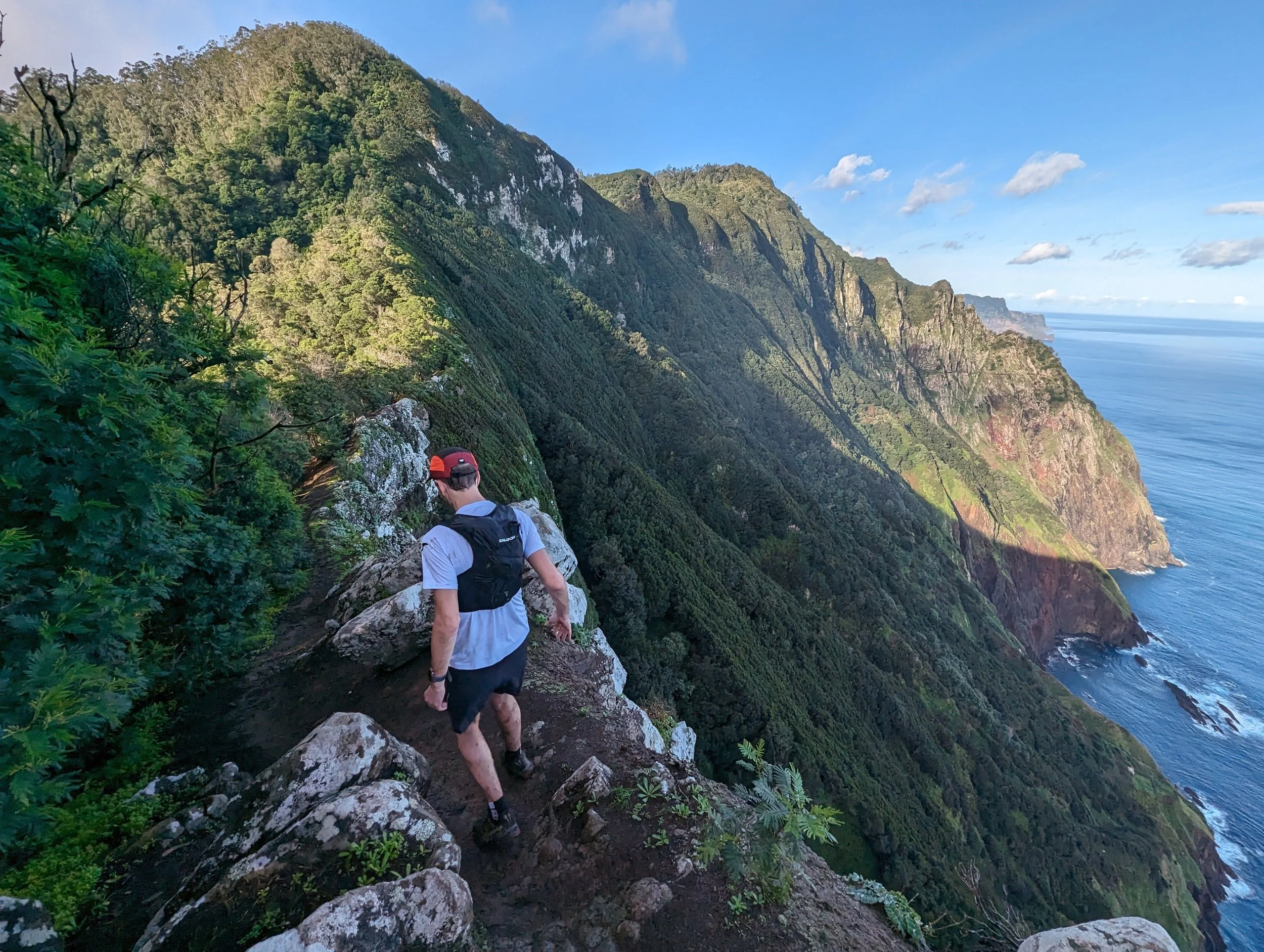
Vereda do Larano: My absolute favorite. After walking through a forest you end up on a cliff with amazing views of the Ocean. I recommend doing this one as a trail run with GoTrail Madeira if you feel like challenging yourself.
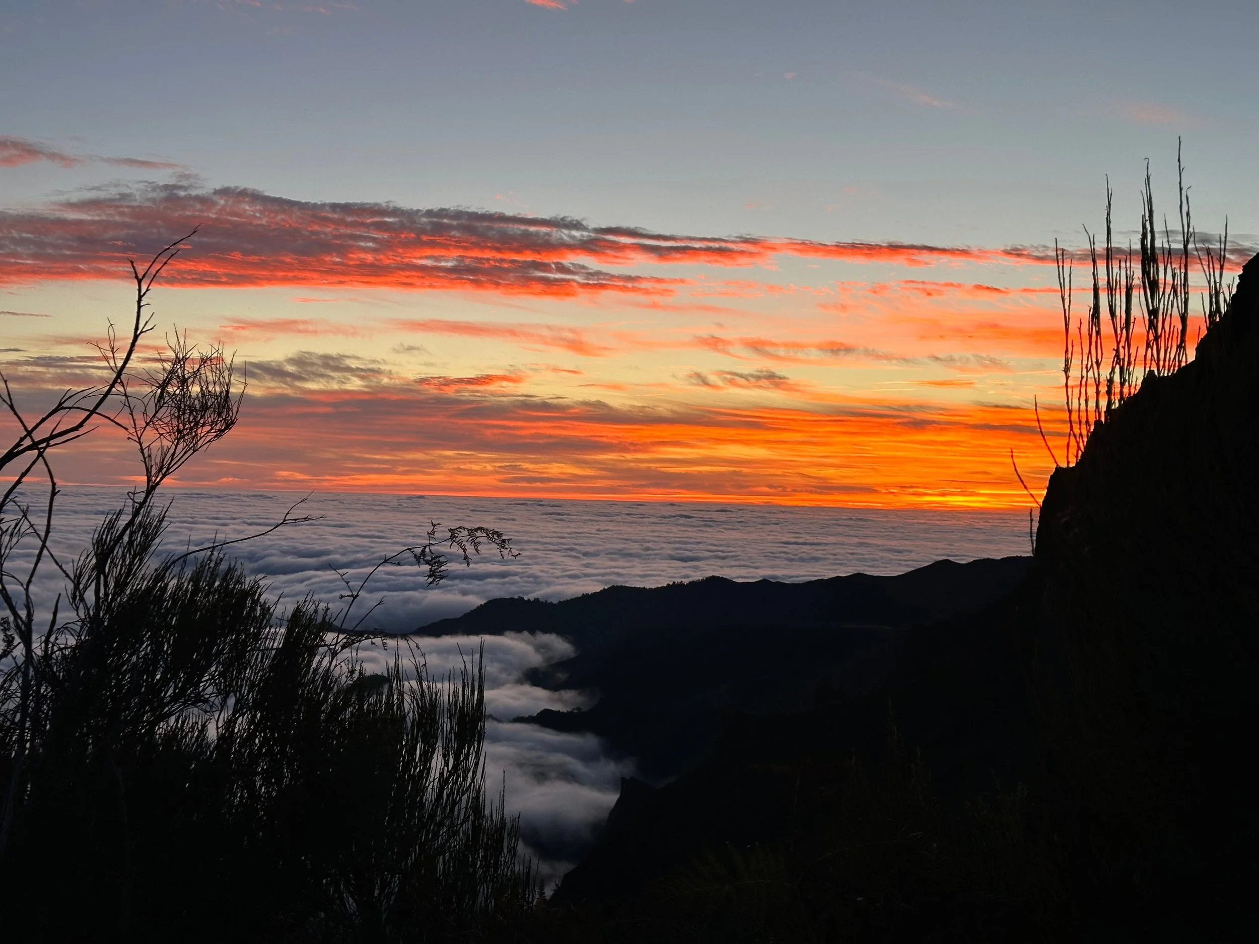
PR 1 - Pico to Pico: Definitely recommend making this a sunrise hike. So you can beat the crowds and enjoy the magnificent sunrise from the trail. You need to get lucky with the weather though. The second time I went there for sunrise the trailhead was covered in clouds. You can check the webcam to get an idea of the weather before you head out.
P.S.: There are webcams for many other locations on the island. While it’s pouring rain on one side, it might be cloudless skies on the other so they really come in handy. A quick Google search will suffice to find these webcams.
Keep in mind you need to park your car and walk 15-20 mins to the trailhead for this hike. So arrive with enough time. There is a viewing point ~1km into the hike that everyone goes to watch the sunrise. We opted to go even further than that and found a spot another kilometer or so in where we were alone and could watch the sunrise in peace.
PR 6 - Levada das 25 Fontes: Has a bunch of waterfalls, including (in my opinion) the most impressive waterfall in Madeira.
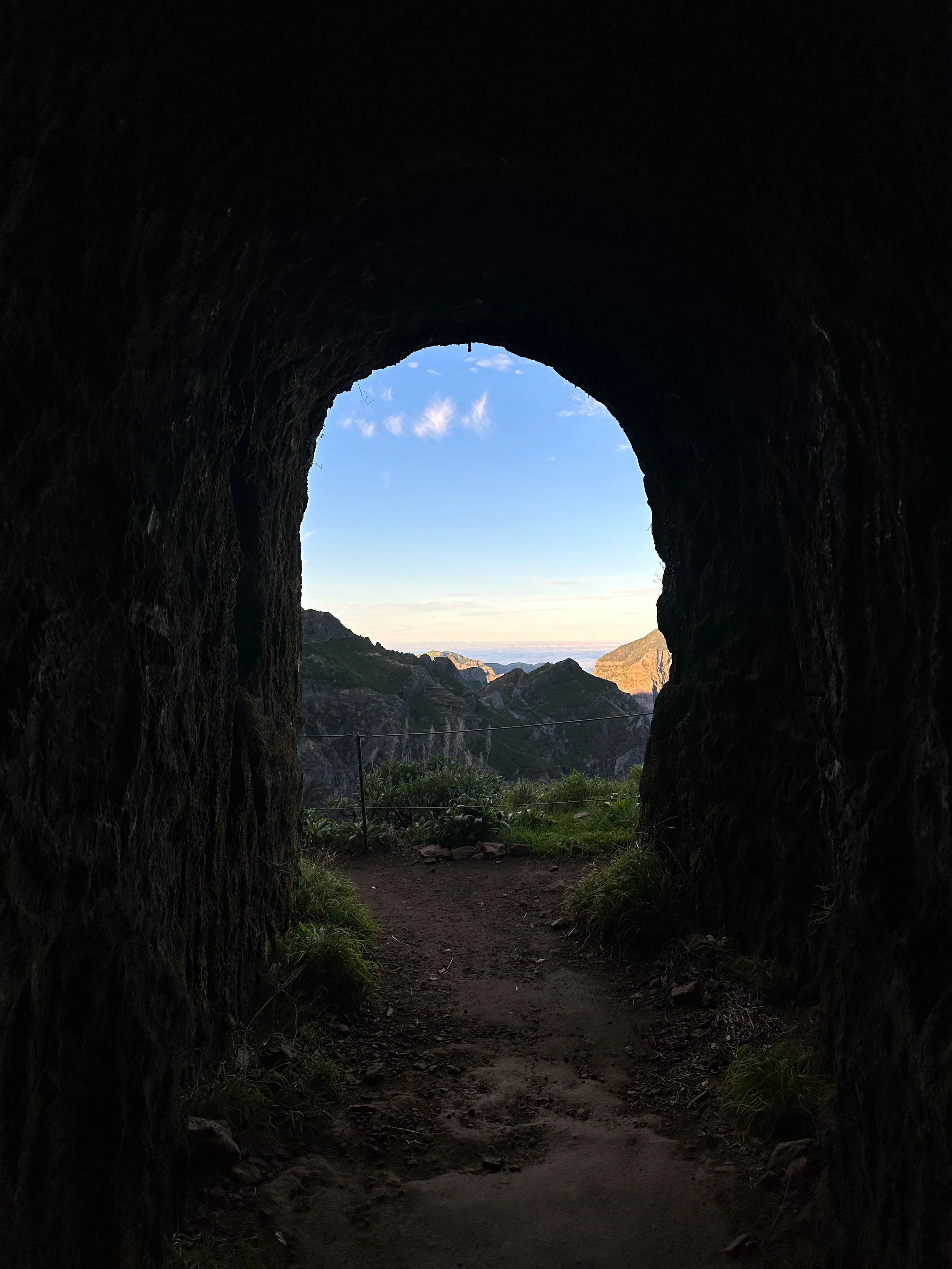
PR 9 - Levada do Caldeirão Verde: Only partially done. Includes a bunch of tunnels and it is a very green path.
PR 13 and/or 14 - Vereda do Fanal: Fanal forest is amazing and unique. Definitely visit it before you leave.
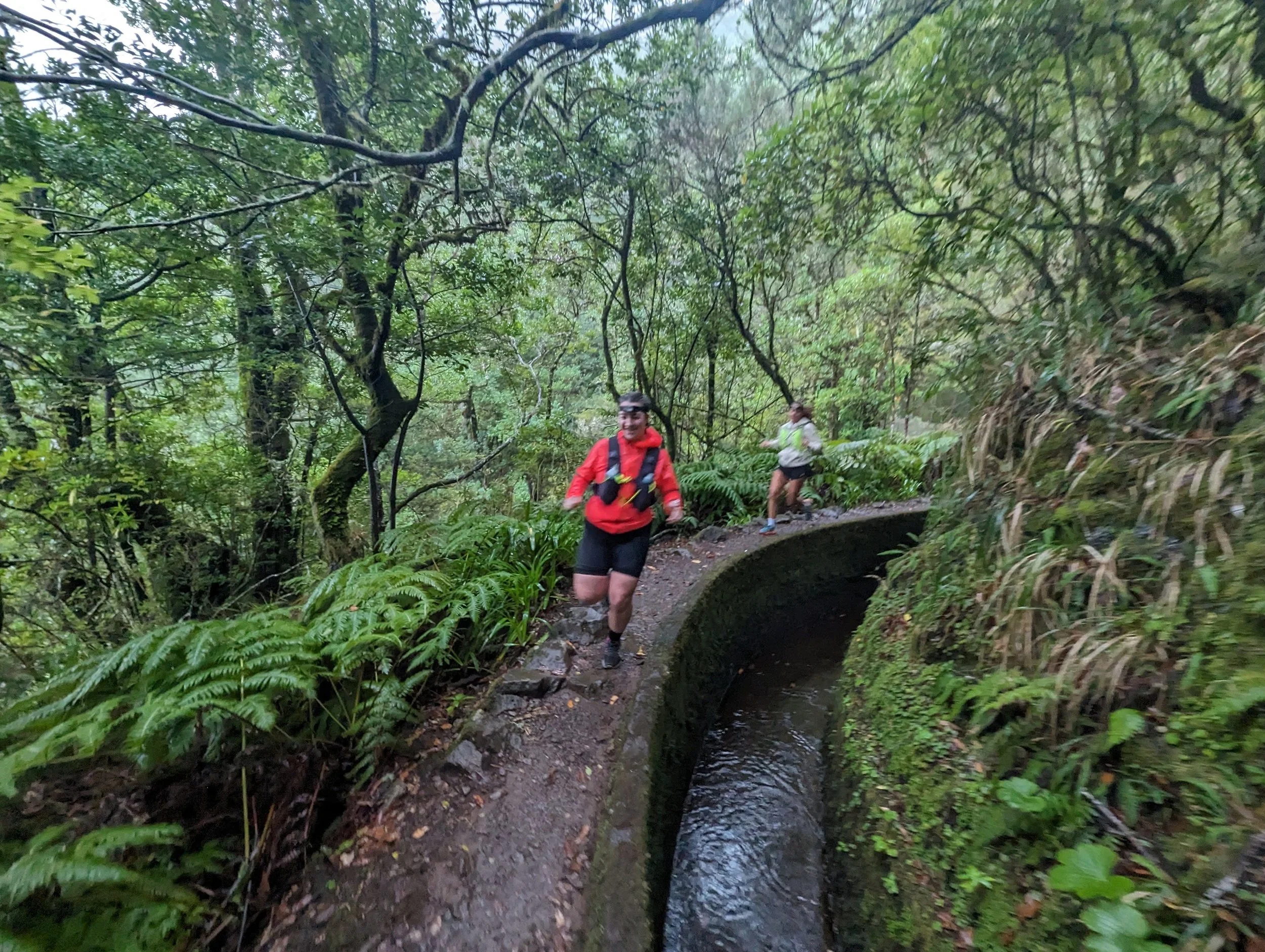
Encumeada (e.g. PR 17): Encumeada is the name of the area in the middle of Madeira. It is very impressive to even drive through it. We did a trail run there with GoTrail which was super fun, going in and out of many tunnels, ending up in magical views covered by clouds which corresponds mostly to PR 17.
PR 2 - Vereda do Urzal: First proper hike we did in Madeira. Great views of the surrounding rock formations.
Ponta de São Lourenço (or PR 8 if you want to make it harder): More like a stroll than a hike (unless you walk the whole way), I would recommend going to the eastern tail end of Madeira for a sunset walk to take in the views as you watch planes fly over you right before landing on the runway.
Navigation apps:
If you use the All Trails App, you will also find most of the trails there with their respective maps. It is slightly inconvenient because some of the recommended paths have multiple entries for their name and they do not always reflect the truth. So take what All Trails says with a grain of salt.
Maps.me is another app that we used which was helpful in times of making our own path and exploring. It is a GPS app that shows you all the paths around you. It does not have any pre-drawn paths in there but you define your own path and see where you are on the map. Great for getting out there and exploring. Very occasionally some of the paths it claimed to exist, did not. So again, be careful while using it.
Some vocabulary:
Levada: Irrigation channel that used to be the main way of carrying water from wetter parts to drier parts of the island. They are accompanied by walking paths.
Vereda: Means path in Portuguese. So any trail that is not a levada is a Vereda.
Pico: Means peak. But not the absolute peak. All higher points in Madeira have names starting with Pico.
Pico Arieiro: Start point of the famous PR1 (Pico to Pico) trek.
Pico Ruivo: Highest point of Madeira.
Poncha: A local favorite cocktail. Made with aguardente de cana, honey, sugar, and citrus fruit. Many people love to have it after a long day of hiking.
Caralhinho: The tool Madeirans use to make Poncha. We learned later from Daniel (our trail running guide and the founder of GoTrail Madeira) that it literally translates to “little penis”. Crucial piece of information. 😄
What you might need:
Water bottle: there are occasional stations to fill water bottles on trails. As tempting as it might be, it is not recommended to drink the water in the levadas. Our guide Daniel said some drink from them, but they also get periodic parasite shots.
Headlamp: there are tunnels on plenty of trails in Madeira. Some of which are very long. Even if it’s a bright day out, you might find yourself in darkness in a tunnel. We found that it is helpful to have a headlamp with us to not waste the precious battery power of our phones and to not have to hold our phones in darkness while trying to not fall into the Levada inside the tunnel on a narrow path.
Layers: even on the sunniest days, higher points in Madeira might feel cold. It’s always a good idea to bring an extra sweater with you.
A dry outer layer: it rains a lot on Madeira. Better be prepared and have a waterproof layer with you.
Trail shoes: I only brought a trail running shoe which is basically a running shoe that has a good grip on rough/muddy surfaces. I did not feel the need for hiking boots but the trails still get tricky with rocks, roots and mud. So use your best judgment.
Knee brace/support: If you already have any knee issues, you might want to bring your knee bands. Madeira has a lot of climbs and descents.
Some first-aid supplies: If you like running around on the trails, you will likely take a few falls here and there. It’s smart to carry around sterile wipes. And for peace of mind, make sure your tetanus shot is up to date, so you don’t need to spend a whole afternoon going from one emergency service to another. [Been there done that. However, they have great hospitals on the island so the experience was overall positive.]
Camping:
Camping is only allowed in designated areas and only with a tent. The camping sites I’ve seen do not allow cars to drive to the camping ground since the camping ground is covered by wooden fences. But there is always space to park your car.
Camping spaces need to be pre-booked. Although some on the internet say you can just go camp at a camping site since someone who booked will likely not show up (it’s free to book) and they rarely check people’s camping permits.
This has one exception which is the camping site at Pico Ruivo. Pico Ruivo is the endpoint of the most popular hiking trail and is the highest point in Madeira and its camping spot is always full (or at least that’s what we heard) because it is a desirable place to camp.
You can also take your chance to wild camp but I’ve heard that sometimes the police use drones to control known camping areas to catch “illegal“ campers. Even if you do wild camp, make sure to not leave a trace. No one wants to run into poopy toilet paper while hiking.
Car rental (and getting around):
I definitely recommend renting a car. It’s very easy to do so and it is affordable. Many of the companies accept debit cards too [RATHER THAN CREDIT CARD ONLY]. Getting around the island with public transport or taxis is not very feasible. If you need a quick ride though, you can use Bolt. There was no Uber when I was there.
Vanscape: small company that has great customer service. Their cars are not the most powerful. There are plenty of steep inclines in Madeira. So you should be okay with going a bit slower on some of them. Their location is not at the airport but they can bring the car to wherever you (incl. the airport) are for a fee.
RentX: Corporate company, professional rather than friendly feel. They have good and powerful cars.
Trail running:
GoTrail Madeira: Found and run by Madeiran locals, you can book guided trail runs with them. You get to run trails that are not on any online guide or map. Very nice local touch to trail running.
Other activities:
For canyoning: FastRope Madeira. We went canyoning on one of our last days in Madeira. It was a heavy rainfall day and other companies deemed it too dangerous to go. But these guys were up for the challenge! Felt very safe the whole time and we had an amazing time. You can reach them on WhatsApp. They respond really fast.